 Ruined Cottage/Moel Siabod
 I had a difficult choice to make last weekend with every single summit in Snowdonia being free of clag. Revisit an old favourite or tick a new summit off my bucket list? In the end I decided to pay the often overlooked summit of Moel Siabod (The Shapely Mountain) a much overdue first visit.
At 872m (2,861ft) it's the highest mountain in the Moelwynion range. Which runs from the North-East of Porthmadog before terminating in Moel Siabod itself, over-looking Plas-y-Brenin (The National Mountain Centre). Plas-y-Brenin situated in the Dyffryn Mymbyr valley, commands excellent views of the Snowdon Horseshoe across the lake of Llynnau Mymbyr, providing a sunning location for the hundreds of courses available there. I can personally recommend it, having spent a weekend there doing the introduction to scrambling course. Playing around on the Glyderau (Senoir's Ridge) and Tryfan (North Ridge).
There are several routes available to the summit of Moel Siabod. On this particular occasion I took what is probably considered the gentlest one. It's also the only one marked on Ordinance Survey maps. Parking alongside the A4086, just after passing Plas-y-Brenin, you take the "Pont-y-Bala" bridge over river Llygwy. Ascending through a Forestry Commission plantation onto the open grassy flanks of Moel Siabod. It's a fairly straight forward, if steep, ascent. But your breath is more likely to taken away by the stunning views that continually open up around you on a clear day. As you near the summit you traverse a boulder field to join the main path that runs along the shattered 800m ridge to the trig-point that marks the summit.
Just as I leaving the summit I was greeted to a stunning display of low-level precision flying by one of the old yellow RAF Search and Rescue helicopters. Swooping over summit before plunging down the eastern cliff faces of Moel Siabod into the hanging valley below, carved out by the glaciers of the last age. Hovering over the shores of Llyn-y-foel for a photo call before leaving us.
These yellow Westland WS-61 Sea King helicopters are synonymous with RAF Search and Rescue and have long been a familiar sight to hill-walkers. Sadly this is probably one of the last times I'll see one of these workhorses in action. In 2006 the government announced controversial plans to privatise the service and the Department for Transport signed a contract with Bristow Helicopters Ltd in March 2013. The new service, operating from 10 bases around the UK using AgustaWestland AW189 and Sikorsky S-92 helicopters, is being phased in over the next two years and will be fully operational by summer 2017. A Sikorsky S-92 was one of the first of the new helicopters to see active service, air-lifting an injured paraglider from Mam Tor in the Peak District at the beginning of Easter.
Anyway back to the walk. The descent takes you along the 800m ridge, over boulders and slabs. A bit of a scramble in places and not perhaps for the faint hearted, but not really full on grade 1 territory either. A shorter stepper ascent/descent is available via an eastern spur running from the summit that takes you back via the aforementioned Llyn-y-foel. This does offer grade 1 scrambling, but even here it's possible to avoid most difficulties by following a reasonably clear, well-worn path. It should also be noted that the valley floor is quite boggy in places and it's not unknown for some of the paths to turn into streams during wet weather. The rock is also quite slippy when wet, so this walk is probably best enjoyed on a dry, clear, day.
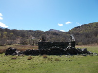
The final leg of the route provides a gentle wind-down, walking along streams and through woods, past a ruined cottage back to the start. Incidentally one image I captured of the cottage with Moel Siabod in the background has provided the inspiration for a short-story I'm currently working on. I hope to put on my blog before disappearing to the Isle of Skye for a week at the end of the month.
At 872m (2,861ft) it's the highest mountain in the Moelwynion range. Which runs from the North-East of Porthmadog before terminating in Moel Siabod itself, over-looking Plas-y-Brenin (The National Mountain Centre). Plas-y-Brenin situated in the Dyffryn Mymbyr valley, commands excellent views of the Snowdon Horseshoe across the lake of Llynnau Mymbyr, providing a sunning location for the hundreds of courses available there. I can personally recommend it, having spent a weekend there doing the introduction to scrambling course. Playing around on the Glyderau (Senoir's Ridge) and Tryfan (North Ridge).
There are several routes available to the summit of Moel Siabod. On this particular occasion I took what is probably considered the gentlest one. It's also the only one marked on Ordinance Survey maps. Parking alongside the A4086, just after passing Plas-y-Brenin, you take the "Pont-y-Bala" bridge over river Llygwy. Ascending through a Forestry Commission plantation onto the open grassy flanks of Moel Siabod. It's a fairly straight forward, if steep, ascent. But your breath is more likely to taken away by the stunning views that continually open up around you on a clear day. As you near the summit you traverse a boulder field to join the main path that runs along the shattered 800m ridge to the trig-point that marks the summit.
Just as I leaving the summit I was greeted to a stunning display of low-level precision flying by one of the old yellow RAF Search and Rescue helicopters. Swooping over summit before plunging down the eastern cliff faces of Moel Siabod into the hanging valley below, carved out by the glaciers of the last age. Hovering over the shores of Llyn-y-foel for a photo call before leaving us.
These yellow Westland WS-61 Sea King helicopters are synonymous with RAF Search and Rescue and have long been a familiar sight to hill-walkers. Sadly this is probably one of the last times I'll see one of these workhorses in action. In 2006 the government announced controversial plans to privatise the service and the Department for Transport signed a contract with Bristow Helicopters Ltd in March 2013. The new service, operating from 10 bases around the UK using AgustaWestland AW189 and Sikorsky S-92 helicopters, is being phased in over the next two years and will be fully operational by summer 2017. A Sikorsky S-92 was one of the first of the new helicopters to see active service, air-lifting an injured paraglider from Mam Tor in the Peak District at the beginning of Easter.
Anyway back to the walk. The descent takes you along the 800m ridge, over boulders and slabs. A bit of a scramble in places and not perhaps for the faint hearted, but not really full on grade 1 territory either. A shorter stepper ascent/descent is available via an eastern spur running from the summit that takes you back via the aforementioned Llyn-y-foel. This does offer grade 1 scrambling, but even here it's possible to avoid most difficulties by following a reasonably clear, well-worn path. It should also be noted that the valley floor is quite boggy in places and it's not unknown for some of the paths to turn into streams during wet weather. The rock is also quite slippy when wet, so this walk is probably best enjoyed on a dry, clear, day.
The final leg of the route provides a gentle wind-down, walking along streams and through woods, past a ruined cottage back to the start. Incidentally one image I captured of the cottage with Moel Siabod in the background has provided the inspiration for a short-story I'm currently working on. I hope to put on my blog before disappearing to the Isle of Skye for a week at the end of the month.
 RSS Feed
