 A relic of a lost community
 I hope you all had a good Easter break. The highlight of mine was a trip to Powys to explore Mynydd Epynt, otherwise known as the Sennybridge Training Area (SENTA). A remote area of Welsh upland sandwiched between Builth Wells to the north and Brecon to the south.
The area has a fascinating and poignant history. At the outbreak of World War 2, the land was requisitioned by MOD who urgently needed more land for training, primarily as an artillery range. The Welsh speaking community who had lived and farmed here for centuries were evicted in June 1940. Resulting in 54 homes being abandoned and 219 people obliged to leave. At the same time a primary school, a church, and the Drovers Arms inn were closed. Although seen as a necessary sacrifice for the war effort, it angered many Welsh nationalists as it effectively moved the Welsh speaking boarder 10 miles to the west. Not helped by the military replacing all the Welsh place names with English ones, when they took over.
The land has continued to serve the military well since the end of the second war. It was used extensively to train troops for the Falkland's War and Afghanistan. Famous for its harsh and changeable weather conditions, it regularly plays host to troops from other NATO nations as well.
The artillery range is still in service today, Permissive paths (free from unexploded shells!) across it are occasionally open to public when live firing exercises are not taking place. In 2003 the Epynt Way was created. A 50 mile walk around and sometimes inside the dry training area. The dry training area being where troops train and learn survival skills without live ammunition (thankfully for those of us walking the Epynt Way).
A visitors centre has also been created in a former farm house that charts the history of the area from pre-history to the present day. The first military occupation of the area taking the form of a Roman Fort between 80 to 140 AD to deal with the local Welsh tribe known as The Ordovices. The visitors centre also commemorates the Welsh community that sacrificed their land to the war effort; Explains the role the land has played as a military training ground for British and NATO forces over the years; And highlights some of the wildlife you can find in what has become an increasingly rare habitat, unimproved grassland.
Spared the ravages of modern, intensive agriculture, frozen in time as it was in 1940, it has become recognised as both an SSSI and SAC (according it protection at the European level for its international importance). I spotted several Red Kites riding the Thermals and Common Lizards basking in the sunshine, during my exploration of the area.
From the visitors centre a wide range of walks for all levels of ability are available, with excellent observation points a short distance from the centre. A challenging 12 mile, circular route, highlighting all the area has to offer is available to the more adventurous walker. This route takes in grassland, peat bogs, small valleys, ravines and numerous stream crossings. You can download a PDF guide to your tablet or phone and marker posts line the route at regular intervals. However I would recommend downloading the GPS file of the route if you have a GPS. As some of the marker posts are missing or damaged and the most obvious path is not always the right one. You also need to be comfortable crossing streams and occasionally boggy ground. This is after all a military training area, so don't expect to find footbridges, boardwalks or stepping stones.
On this route you'll also have a long (3 mile) road walk back to the start. A small price to pay for exploring this remote upland area and perhaps a welcome break after all the stream and bog hopping. You'll also encounter one of the many former farmhouses and the Drovers Arms on this section of the route. Following a campaign by the Fellowship for Reconciliation in Wales signs now give the original Welsh names of these places in memory of the community that lived here.
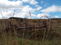
The Drovers Arms, now a troop shelter, once stood at the heart of a network of ancient droving routes that date back to at least Medieval times. It would have been an important watering hole for drovers taking sheep and cattle to the fairs and markets in England. Sadly it no longer serves ale to the passing traveller.
Best of all, on a day, when a few miles away, people were queuing to have their photos taken on top of Pen-y-Fan I was the only civilian walking the Mynydd Epnyt or 'Mountain haunt of the horse' (the wild ponies that use to roam here were relocated by the military in 1940).
There are a wealth of resources on the internet about the area and its history from a number of perspectives. Although the English language version of 'An Uprooted Community A History of Epynt' published in 1998 no longer appears to be in print and will set you back £60 on Amazon.
Whatever your view, I would recommend visiting this beautiful area of Welsh upland and pondering its history past and present. The lives of the people who have lived and worked here and enjoying the rich and varied wildlife it holds.
The area has a fascinating and poignant history. At the outbreak of World War 2, the land was requisitioned by MOD who urgently needed more land for training, primarily as an artillery range. The Welsh speaking community who had lived and farmed here for centuries were evicted in June 1940. Resulting in 54 homes being abandoned and 219 people obliged to leave. At the same time a primary school, a church, and the Drovers Arms inn were closed. Although seen as a necessary sacrifice for the war effort, it angered many Welsh nationalists as it effectively moved the Welsh speaking boarder 10 miles to the west. Not helped by the military replacing all the Welsh place names with English ones, when they took over.
The land has continued to serve the military well since the end of the second war. It was used extensively to train troops for the Falkland's War and Afghanistan. Famous for its harsh and changeable weather conditions, it regularly plays host to troops from other NATO nations as well.
The artillery range is still in service today, Permissive paths (free from unexploded shells!) across it are occasionally open to public when live firing exercises are not taking place. In 2003 the Epynt Way was created. A 50 mile walk around and sometimes inside the dry training area. The dry training area being where troops train and learn survival skills without live ammunition (thankfully for those of us walking the Epynt Way).
A visitors centre has also been created in a former farm house that charts the history of the area from pre-history to the present day. The first military occupation of the area taking the form of a Roman Fort between 80 to 140 AD to deal with the local Welsh tribe known as The Ordovices. The visitors centre also commemorates the Welsh community that sacrificed their land to the war effort; Explains the role the land has played as a military training ground for British and NATO forces over the years; And highlights some of the wildlife you can find in what has become an increasingly rare habitat, unimproved grassland.
Spared the ravages of modern, intensive agriculture, frozen in time as it was in 1940, it has become recognised as both an SSSI and SAC (according it protection at the European level for its international importance). I spotted several Red Kites riding the Thermals and Common Lizards basking in the sunshine, during my exploration of the area.
From the visitors centre a wide range of walks for all levels of ability are available, with excellent observation points a short distance from the centre. A challenging 12 mile, circular route, highlighting all the area has to offer is available to the more adventurous walker. This route takes in grassland, peat bogs, small valleys, ravines and numerous stream crossings. You can download a PDF guide to your tablet or phone and marker posts line the route at regular intervals. However I would recommend downloading the GPS file of the route if you have a GPS. As some of the marker posts are missing or damaged and the most obvious path is not always the right one. You also need to be comfortable crossing streams and occasionally boggy ground. This is after all a military training area, so don't expect to find footbridges, boardwalks or stepping stones.
On this route you'll also have a long (3 mile) road walk back to the start. A small price to pay for exploring this remote upland area and perhaps a welcome break after all the stream and bog hopping. You'll also encounter one of the many former farmhouses and the Drovers Arms on this section of the route. Following a campaign by the Fellowship for Reconciliation in Wales signs now give the original Welsh names of these places in memory of the community that lived here.
The Drovers Arms, now a troop shelter, once stood at the heart of a network of ancient droving routes that date back to at least Medieval times. It would have been an important watering hole for drovers taking sheep and cattle to the fairs and markets in England. Sadly it no longer serves ale to the passing traveller.
Best of all, on a day, when a few miles away, people were queuing to have their photos taken on top of Pen-y-Fan I was the only civilian walking the Mynydd Epnyt or 'Mountain haunt of the horse' (the wild ponies that use to roam here were relocated by the military in 1940).
There are a wealth of resources on the internet about the area and its history from a number of perspectives. Although the English language version of 'An Uprooted Community A History of Epynt' published in 1998 no longer appears to be in print and will set you back £60 on Amazon.
Whatever your view, I would recommend visiting this beautiful area of Welsh upland and pondering its history past and present. The lives of the people who have lived and worked here and enjoying the rich and varied wildlife it holds.
 RSS Feed
